Lumbering Toward a Long-Held Vision for a New I-35
Riding on TxDOT's endless highway
By Mike Clark-Madison, Fri., Jan. 27, 2023


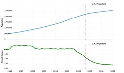
According to the 2020 census, the median-age Austinite is 33.7 years old. That means half of the people in town now were not yet born when the Texas Department of Transportation began its journey to rebuild I-35 through the heart of the city, with a "major investment study" that commenced in 1989. Back then, the Austin metro area was home to fewer than 600,000 people; today, it's 2.23 million.
That journey is now in its penultimate chapter, as TxDOT has finally gotten to the point of releasing its draft environmental impact statement, or DEIS, for the 8-mile stretch of I-35 between U.S. 290 East (the Manor Expressway) and U.S. 290 West (Ben White Boulevard). February 9 is the mandatory public hearing that must be held on the DEIS, with comments being accepted through March 7; likely this fall, TxDOT will produce the final EIS along with a "record of decision," which allows it to move forward with what it now calls the Capital Express Central project.
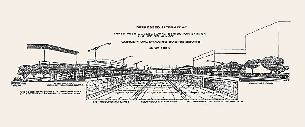
Deep, deep into the 7,000 pages of material in the DEIS is a deep cut from TxDOT's back catalog: Appendix U contains a presentation of "IH 35 Design Concepts Through Austin" from 1994, delivered by the TxDOT Austin district to what was then the Austin Transportation Study and is now CAMPO (the Capital Area Metropolitan Planning Organization). In the main body of the DEIS, which clocks in at a svelte 517 pages, Appendix U is cited exactly once – at the beginning of Chapter 2.0, "Alternatives Including the Proposed Action," which references the 1989 MIS ("Beginning as far back as the late 1980s, TxDOT recognized the need to upgrade I-35 through the region to provide improved mobility") and then summarizes seven more planning efforts from 2009 to 2020 that "have informed the reasonable alternatives that were carried forward for further study in this DEIS." But what's striking is how much those 1994 renderings in Appendix U look like the ones TxDOT has created for the CapEx Central.
There are also Capital Express North and South projects, which cover the segments of I-35 to State Highway 45 North and South, or basically the Travis County line. Those projects are already underway, having qualified for a more streamlined version of environmental review than the Central.
Everything Old Is New Again
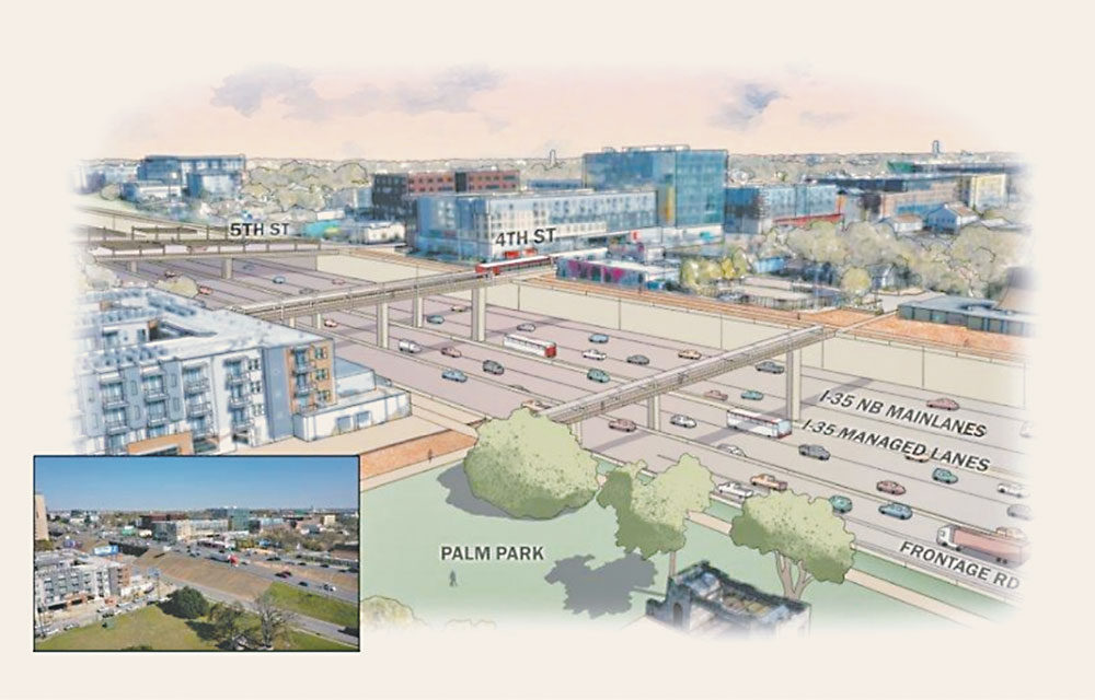
The 1994 presentation includes rendered cross-sections of a highway of about 20 lanes, including new high-occupancy lanes and frontage roads, with the mainlanes variously at grade with, elevated above, or depressed below the adjoining city blocks; the latter of these approaches is what TxDOT now envisions for the CapEx Central, which includes two new "managed" lanes in each direction. (Managed how? Since Texas is "in a non-tolled environment," as the DEIS dryly puts it, they'll be HOV lanes and available to buses.) The "goals/visions" included with those 1994 renderings contain themes that have echoed throughout the generations into the "purpose and need" statement that, under the review process established by the National Environmental Policy Act, defines the criteria by which I-35 alternatives should be evaluated.
These include maximizing the carrying capacity of the constrained I-35 corridor; improving access to Downtown, the Capitol Complex, and UT-Austin while accommodating through traffic; developing "interfaces" between the highway and surface streets, transit (including "light rail," which also proved to be several generations away), and destinations such as the Austin Convention Center, or what's now more broadly defined as the Palm District and Rainey Street. "Funding issues and a lack of political and public support," the DEIS reads, "prevented further advancement of these concepts at the time; however, portions of these concepts have been incorporated into later studies."
The current DEIS, unlike the 1994 vision, specifically calls out improving safety, both along and across the corridor and for pedestrians and cyclists as well as drivers, which is all good, but that's the most significant difference. The effect, if not stated explicitly, is to suggest that I-35 reconstruction as a highway with more lanes than it currently has, some of which are "managed," remains the best, if not only, possible way within TxDOT's power to address congestion, safety, and environmental deficiencies along this 8-mile stretch of highway: See, we've been studying this for more than 30 years, and the basics have remained unchanged. What else can we do?

As you know from reading the Chronicle, there are different answers to that question than the one TxDOT keeps arriving at. If Austin really put its mind to it, we could make peace with a future in which I-35 didn't exist at all, at least as part of the urban core – one where local traffic was distributed through improved city streets (and on freeways that didn't exist in 1994, such as U.S. 183) and where a bunch of trips into the city center could be handled by a robust mass transit system. (This is more or less what the Rethink I-35 community coalition wants to see.) That would be more in keeping with the city of Austin's mobility and environmental goals, which call for a significant reduction in the share of trips made by driving alone, which is perhaps the biggest contribution to climate change that we each make.
Is there hope for a consensus around something like this – not just "no build," which under NEPA is always an alternative to be studied, but un-building I-35 in some meaningful way – to emerge before TxDOT breaks ground on its preferred I-35 alternative (Modified Alternative 3, or Mod-3)? Probably not. For one thing, this plan has a decades-long head start; for another, the transit system we need – Project Connect – still does not exist and is having its own funding issues.
Perhaps most importantly, for many mobility decision-makers in Central Texas (including both the current and past Austin mayors, each also a former chair of CAMPO), the progress made to date on the CapEx Central represents a major victory, the fruit of heroic measures to forge a useful collaboration between the city of Austin, its regional neighbors, and the state. Central city progressives who want a narrower, less intense I-35 have to date been fortunate in avoiding having to pick fights with suburban drivers who have no problem with TxDOT adding lanes to the interstate. But one imagines the latter are out there and could get politically active if need be.
The Road Beneath Our Feet
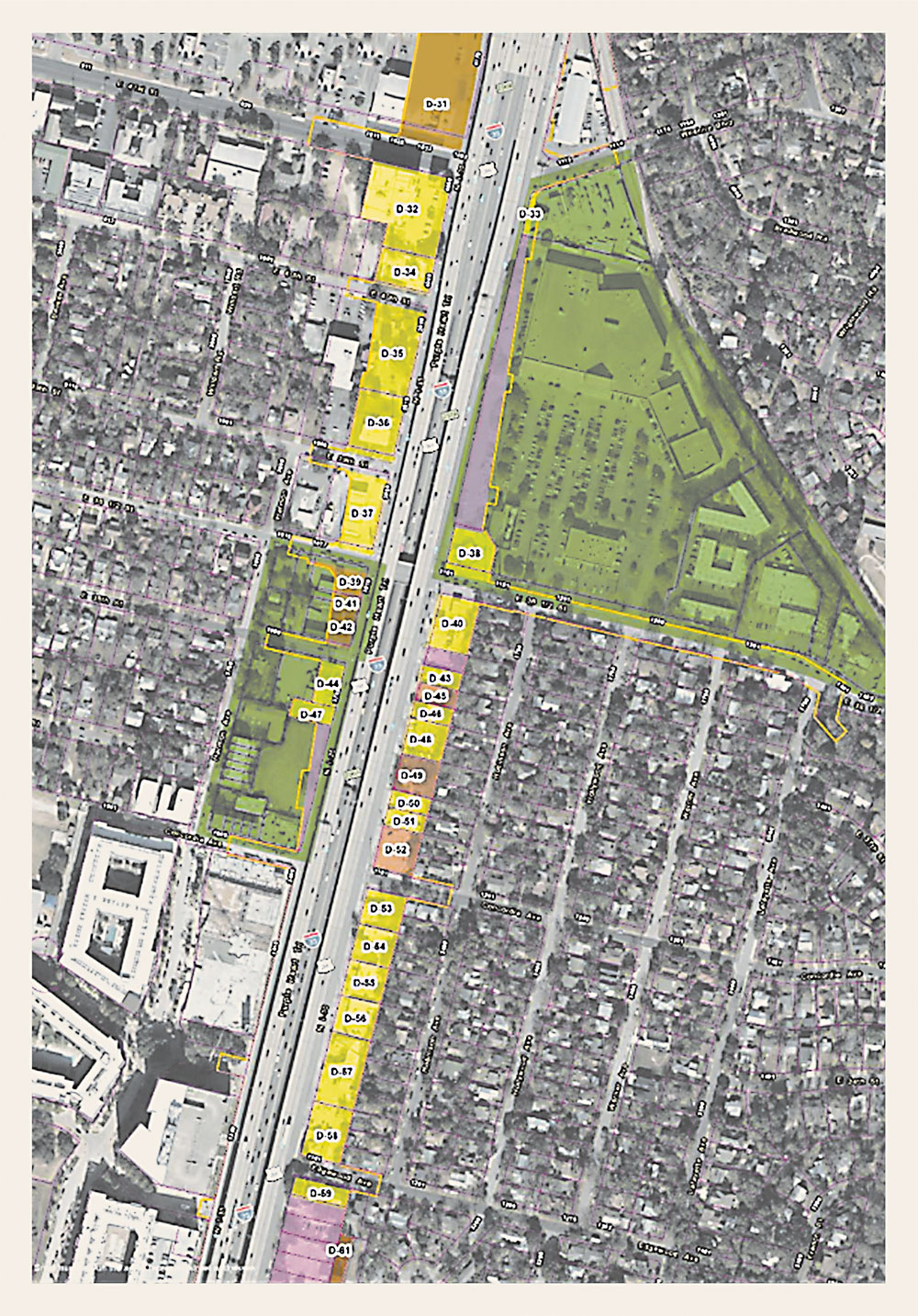
Wait, you might be thinking, isn't TxDOT going to cover most of the highway? Isn't that how it's responding to what the community says it wants? A mantra of recent years in the I-35 saga has been that a rebuilt highway would be "no wider and no higher" than it is now. Since TxDOT plans to take down the upper deck between MLK and Airport boulevards, making the resulting one-level (below-grade) highway "no wider" has proven to be beyond TxDOT's abilities, although Mod-3 results in displacing about half as many residents and businesses as "Alternative 2," which took out an entire affordable housing complex, oops. (One of those displaced is the Chronicle office; read more.)
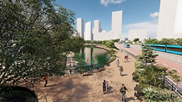
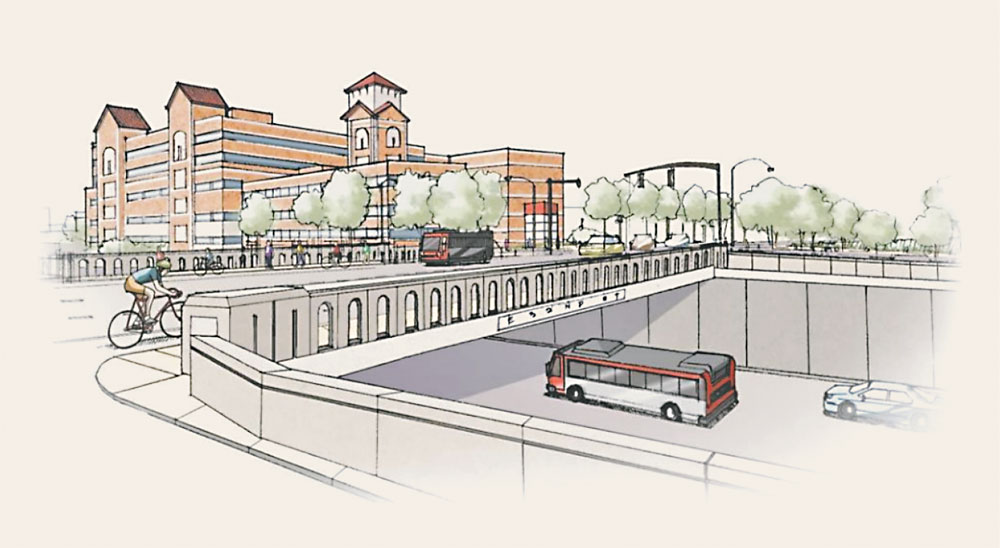
But "no higher" is still on the table, and Mod-3 allows for the construction of nearly 34 acres of "deck plazas" over the depressed mainlanes. These would not only be in Downtown Austin but also along the east side of the UT-Austin campus, where the university has realized it could use this new land to solve space and access problems faced by the sports and entertainment facilities clustered by the I-35 frontage. The decks are ostensibly strong enough to support one- and two-story buildings, or the Longhorns' inflatable practice bubble, and the frontage roads may "meander" from one side to the other across it, in keeping with the "boulevard" treatment TxDOT wants to deploy rather than placing one-way frontage roads on each side.
However, TxDOT makes quite clear that the deck plazas, as well as extra-wide bridges and landscaped "stitches," are "enhancements" that it does not feel it can fund out of Texas' highway dollars. The preliminary estimate, which is pretty rough, is that the Mod-3 deck enhancements would cost somebody – the university, perhaps the city, perhaps the flush-with-cash federal government, perhaps something else – around $800 million. If that money is not locked down by the time TxDOT gets ready to go out to bid for construction, then the deck plazas would apparently turn into pumpkins, and East and West Austin will lie on opposite sides of a wide ditch, although one whose east-west crossings are safer than they are currently.
This would probably be an unacceptable outcome for many, including perhaps the Federal Highway Administration, which has delegated its authority to review the DEIS to TxDOT but can always intervene if it thinks things are getting way off course, as it did in Houston when the I-45 expansion project got TxDOT sued by Harris County (the sides there have reached an apparent compromise). Would an un-enhanced Mod-3, even if better on some measures than the status quo, really pass environmental muster? Aren't the decks and bridges and stitches arguably necessary to mitigate the damage that a wider, deeper I-35 could do? This is a point being raised by the Chronicle's across-the-highway neighbors in Cherrywood, who would like to see the deck plazas continued north of campus so they won't be cut off.
Lowering the Barriers
To be clear, "environmental review," as conducted under NEPA, involves more than impacts to air and water quality, endangered species and habitat, and the like, although it does include assessments of those. (And also of the project's contribution to greenhouse gas emissions, even though that's not a "decisional" factor for TxDOT.) The NEPA process calls for an in-depth look at all the places, and often the people, along the project alignment that could merit protection under federal law; that's why people like Sen. Joe Manchin want to reform and streamline it. Some of those statutory protections are well known and understood by people who build roads for a living, such as those for Waters of the United States – a federal regulatory regime under attack from conservatives right now – or for National Register-eligible properties, or for parkland or farmland that may be rendered unusable.
Others are less clear-cut. While both state and federal law requires agencies such as TxDOT to do an environmental justice analysis of how their proposals could impact low-income communities and communities of color, there's a fair amount of discretion as to what variables to look at. That's more important in a case like I-35, where the no-build alternative is held near-universally to already harm those communities, and to have done so for decades by being a sturdy barrier between East and West Austin.
Strictly speaking, the agency simply has to avoid making things worse with the current project, but TxDOT's Austin district engineers live here too and they know the politics and the symbolism of I-35. After acknowledging that the interstate was built along the former East Avenue corridor, "which was seen effectively as a racial divide in Austin's early history," the DEIS reads, "TxDOT understands the significance of I-35 to the local community and the present chance to address local concerns with development and implementation of the Capital Express Central Project." (Emphasis ours.)
"This project offers the option to remove the visual separation and provide opportunities to reconnect the communities and spaces east and west of I-35," the DEIS continues, by "removing the upper decks and elevated lanes, lowering of I-35 through the downtown core, and rebuilding the east/west bridges for wider and safer bicycle and pedestrian crossings." The agency is working with local and community partners "to allow for deck plazas and stitches (funded by others), or widened bridges, to be developed and to rebuild I-35 in a way that encourages transit and meets the needs of commuters and people who walk and bicycle." (Emphasis ours, again.) Lowering the barrier – even, presumably, by turning it into a ditch – in TxDOT's view improves upon the status quo. But covering the ditch would be even better.
As we've reported, these design concepts come from what TxDOT calls "the community alternatives" – the visions for not just rebuilding but reinventing I-35 that have been advanced by the Reconnect Austin and Rethink I-35 coalitions, as well as the Downtown Austin Alliance and Urban Land Institute. The Reconnect proposal calls for the highway to be buried under its own access roads Downtown, thus freeing up much of the current I-35 right-of-way for development that can help pay the $4 billion price tag for the CapEx Central; Rethink I-35 wants it to be abandoned entirely in lieu of a broad boulevard, as has been done in highway-removal projects in cities around the country.
Point being, they're not just design concepts but genuine operational alternatives to the once and future interstate. TxDOT asked the Texas Transportation Institute to weigh the community alternatives back at the beginning of the EIS process, and it was concluded that they failed to meet the purpose and need of the project. However, the agency decided to embrace the design concepts themselves and add them to, rather than substitute them for, its core concept.
For TxDOT's purposes at present, it doesn't really matter how the deck plazas, enhanced bridges, and stitches would be utilized in the future, whether as "enhancements" or as potential mitigations of a negative environmental impact, particularly an environmental justice impact. But it's a question that the city and community stakeholders who want to make sure the caps get built should start raising in public. Generically, they are rendered in TxDOT's drawings as open space, perhaps to be used recreationally but not programmed. Speculation about any kind of structures or roadways upon them, which is central to the Reconnect concept, is for the moment limited to the campus section and remains very high-level.
The $800 million-plus for construction of the caps, etc. does not include the cost of programming them with either active or passive uses. Right now, you may be aware, the city parks department is focused on reducing its responsibilities for Central Austin green space – the Butler Trail along Town Lake, Pease Park along Shoal Creek, and Waterloo Park on Waller Creek, all are now effectively in the hands of nonprofit partners. Austin voters also approved allowing the city to swap some of its land on the south shore of the lake with neighboring Oracle Corp.; creating a new program, in either public or private hands, to manage 33 more acres of parkland could be seen as unwelcome competition for the Waterloo Greenway a couple of blocks away. Despite TxDOT's having the finish line of the formal CapEx Central NEPA process in sight, there is still a lot more work to be done before all these challenges are resolved.
How to Get Involved
View the draft Capital Express Central EIS document online at my35capex.com/draft-eis; at the TxDOT Austin District Headquarters at 7901 N. I-35; at the Austin Public Library's Carver (1161 Angelina), Ruiz (1600 Grove), and Southeast (5803 Nuckols Crossing) branches; and at the Montopolis Rec Center at 1200 Montopolis Dr.
You can submit comments online, at the Feb. 9 public hearing, by email at [email protected], by voicemail at 512/651-2948, or by mail to I-35 Capital Express Central Project Team, 1608 W. Sixth St., Austin, TX 78703.
I-35 Capital Express Central Public Hearing
Thursday, Feb. 9, 5-7pmMillennium Youth Entertainment Complex, 1156 Hargrave
TxDOT will host a virtual public hearing with an in-person option to gather input on proposed improvements on I-35 from U.S. 290 East to Ben White. The purpose is to request public comment on the draft environmental impact statement and to present the preferred alternative. Comments received by Tuesday, March 7, will be included in the official public hearing record.
I-35 Town Hall Hosted by City Council Districts 2, 3, 4, 5, 9
Thursday, Feb. 2, 6-7:30pmPermitting and Development Center, 6310 Wilhelmina Delco
RSVP
Five City Council members – Fuentes (D2), Velásquez (D3), Vela (D4), R. Alter (D5), and Qadri (D9) will host a first-of-its-kind I-35 town hall that will allow participants to deep-dive into schematics, provide feedback directly to Council members, and encourage to participate in TxDOT's public hearing the following week.
Got something to say on the subject? Send a letter to the editor.