As Austin Grows, So Does the Risk of Flood
Forget the 100-year storms. City flooding happens all the time, often right in your backyard.
By Joseph Caterine, Fri., April 21, 2017


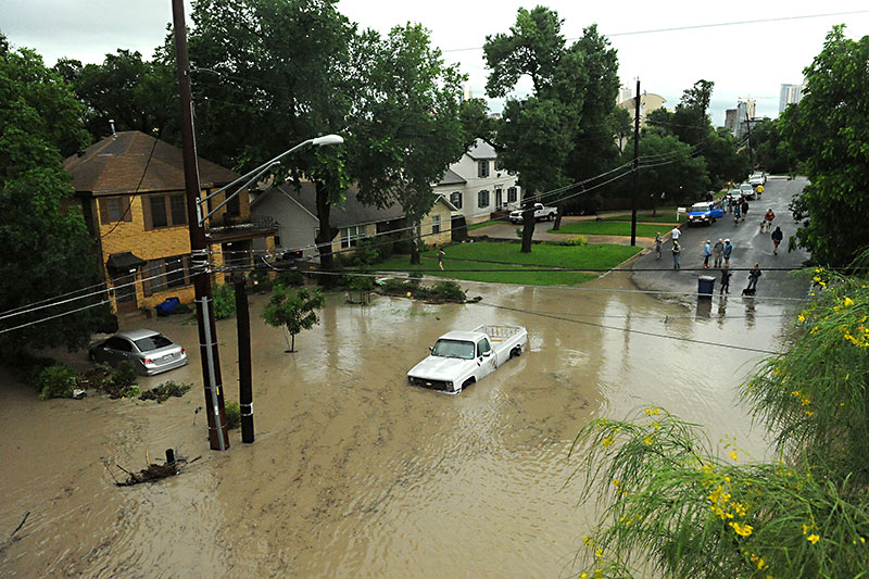
Austinites remember the big floods – the expanding, treacherous storms that ransack homes and uproot families. But just beyond the memory of those squalls, another form of watery overflow has washed into town its own ruinous legacy: localized flooding.
The city's topographical condition within Texas' expansive geography makes it a common target for big storms. The Balcones Escarpment, the cliff formation that separates the Hill Country from the state's coastal plains, acts as a ramp for incoming weather systems arriving from the Gulf of Mexico, producing an orographic lift (when an air mass rapidly changes altitude and creates clouds or precipitation) that can dump torrential rainfall on cities west of the fault. That's not to say cities in East Texas don't get their fair share of wet weather. In fact, the eastern region's annual rainfall average usually registers 10 to 15 inches higher than in Central Texas. (Houston's average is 49.77 inches per annum; Austin's is 34.25.) Less rain means drier soil, which makes creeks less able to handle torrential downpour. In the context of Austin's gradients, that's a recipe for nasty business.
On Memorial Day weekend in 1981, several hours of storms pounded the city, quickly overwhelming its waterways. Shoal Creek's flow, usually 90 gallons of water per minute, at its peak was processing 6 million gallons in the same period. Thirteen people drowned, and many had to be rescued from roofs and stranded vehicles by city personnel. Local businesses took a tremendous hit. Onlookers spotted pianos from Strait Music (then located on North Lamar) floating down the street, converging with cabinets and tables from the nearby Louis Shanks. Whole Foods Market, at the time headquartered at Ninth Street, lost its entire inventory. In a video interview recorded by the city in 2011, Senior IT Coordinator David Matthis recalled witnessing the immediate aftermath of the floods. He and company founder John Mackey drove down to Lamar to check on the store when the rain began subsiding. "We realized that some disaster had befallen the city," he said.
"The 1981 flood brought a lot of focus to flooding issues in Austin," explained Jose Guerrero, assistant director for the city's Watershed Protection Department. Later that year, voters approved a public works bond to fund the buyouts of damaged houses near Shoal Creek; numerous detention ponds (pits designed to temporarily counteract runoff); and other flood mitigation improvements. (Such efforts were detailed in the first issue of this paper.) In 1991, the city implemented a flood early warning system – an array of alarm gauges triggered by water surges – and introduced a drainage charge to secure funding for flood mitigation measures moving forward.
Vested with reliable financial backing, the city could begin to tackle larger projects. In 2004, construction was completed on the Crystalbrook drainage system and floodwall, a 5,700-foot levee built to protect the eponymous neighborhood from Walnut Creek flooding. The project cost the city $14.5 million, $700,000 of which came out of the drainage utility fund. "That neighborhood flooded frequently," remembered Guerrero. "Once those improvements were done, you should have seen the turnaround in that community."
After completing a few other costly flood mitigation projects over the last 15 years, WPD estimates that it has reduced the danger of creek flooding for over 1,500 structures in Austin. Despite all this, the department's propensity for high-cost flood mitigation projects at the expense of its drainage utility fund has been criticized by certain experts. A research paper written in December 2015 by former UT master's student Adrian Zeh, in collaboration with Eastside nonprofit PODER, illustrated through open records requests that 85% of drainage fee spending goes into active capital improvement projects costing more than $250,000. Most of those projects go toward protecting parks and the densest areas of the city. Zeh found that one Downtown tract received 31% of all active capital improvement spending, while 71% of the city's tracts received none. "For residential residents, and even business owners outside of Downtown, it certainly does not seem fair to pay into [the drainage utility] that goes to address drainage issues distant from you, and rarely addresses local residential flooding concerns," Zeh concluded.
"Rarely" may be a stretch, but according to WPD's own projections in 2015, the cost estimate for primary drainage systems (for creek floods) sits close to $1.5 billion (including erosion control), whereas the cost for storm drainage systems (for localized flooding) sits between $700-800 million. According to engineer Dr. Lauren Ross, this disparity in spending reflects an imbalance in the city's flood mitigation priorities, in which guarding against the danger of the massive floods in some ways eclipses the collective threat generated through smaller storms. "I think we have more robust programs in place to protect the community from the big river floods than the local drainage floods," she said.
Takes Place in Your Roadspace
Creek floods make the headlines. The 2013 and 2015 floods of Onion Creek both captured national attention, with the Watershed Protection Department reporting at least four deaths and nearly 825 damaged structures, and neighbors lobbing accusations of negligence at city officials. Ana Aguirre, a Dove Springs community member who served on the Flood Mitigation Task Force, said she remembers witnessing the aftermath of the 2013 Halloween flood when she volunteered to participate in the cleanup of lower Onion Creek. "Being there and helping people dig whatever they had left out, and trying to get the sheetrock pulled off the walls," she said, "and then coming home and being told to throw away what I was wearing because there were chemicals in the water ... if people haven't seen that sort of thing, they don't know what it's like."
Terrible as natural disasters can be, there are far more instances of localized flooding that take place around the city every year. "They often just mean that you can't drive through a roadway, or maybe it backs up a few inches in your house," said Ross. "They are not as life-threatening. They are not going to send you up on your roof having to use an axe through your attic. So the city is slower [to respond]. It costs a lot of money to come in and tear up the streets and put in bigger pipes. They are harder problems to address."
In order to optimize the allocation of its resources, WPD uses a "problem score" system for its four main flood mitigation categories: creek floods, localized floods, erosion control, and water quality protection. Unlike creek flood problem scoring, wherein WPD leverages sophisticated hydrologic and hydraulic computer models to identify vulnerable areas, localized flooding problem scoring relies heavily on human observation. By the end of last June, WPD had received 6,235 total complaints through 311, citing yard, building, or street flooding, since it started collecting the information in 1988. This information is supplemented by one-dimensional computer models, although only 65% of the city's secondary drainage systems have been mapped in this way.
Of the 1,080 miles of storm pipe that run under Austin's streets, 257 were constructed before 1977 when the city adopted modern engineering criteria. Today, city code mandates that public drainage be outfitted to convey storm events that range from 25-year storms to 100-year storms. Old pipes are not the only problem, however: Today, the capacity of up-to-date systems is being strained more and more by tempests of development. "Drainage is a unique utility in that you can put a system in, but if it's undersized and development accumulates over time, the problems with flooding don't typically surface until maybe 10 to 20 years down the road," Guerrero said.
To build within the city, a developer must follow many strict regulations, including those concerning stormwater management. There are limits to impervious cover depending on the parcel's zoning, and floodplains must be kept at a safe distance. If it is determined by city staff that a project will cause excess runoff, the developer must either dig on-site detention ponds or pay a fee into the Regional Stormwater Management Program (RSMP), a repository that the WPD can draw out of to fund mitigation projects in the same area.
While these measures improve the likelihood that runoff from a particular development will either be contained or conveyed to a river or reservoir, it is harder to control how water can reach its predicted destination. "Somehow the path of water can change," explained Planning Commissioner James Shieh. "That path may not even be on the developer's site. They dump it off where they need to, and then somehow it gets to the final floodplain or reservoir, but was the infrastructure on the path in between upgraded to take care of that? A development doesn't just affect that piece of property; it affects property many blocks away."

Over the past six years, multiple complaints have been filed with the city from residents along South Lamar concerning area flooding. At first, the pattern seemed incidental, but after months of investigation and collaboration between the city and neighborhood, it became evident that the wave of development on South Lamar had disrupted the flow of stormwater from the Zilker neighborhood, which must cross over Lamar in order to drain into West Bouldin Creek. In their study of the area, the WPD discovered that more building permits and site plans had been granted for the South Lamar corridor during that timespan than for anywhere else in the city. Individually, these developments had passed the city's flood mitigation requirements, but together they had inadvertently redirected water onto residential properties.
The South Lamar Neighborhood Association was eventually able to pass a mitigation plan to revamp the drainage on Thornton, Kinney, and Bouldin Creek, as well as install a new system along Bluebonnet Lane and Del Curto. SLNA president Kim Johnson anticipates the improvements will take at least six years to reach completion.
There Goes the Neighborhood
Localized flooding has tormented neighborhoods like South Lamar, Brentwood, Hyde Park, and Pemberton Heights – neighborhoods which can in turn rally to advocate for community needs. But more often than not, it singles out specific households that are forced to fend for themselves.
Steve Wood lives in Barton Oaks, a subsection of the greater South Lamar neighborhood that rests along the northbound side of MoPac. Three years ago, he caught wind of plans for a new 31-unit, single family attached development adjacent to his property: Lightsey II, a project by PSW Homes, was set for a 4-acre tract at a higher elevation than his house. He doubted city requirements "were stringent enough to protect my property," he said, so he hired his own civil engineer to inspect PSW's plan.
"There were some things that my engineer thought could be beefed up pretty easily, and their engineer agreed," Wood said. So the company made some changes. "Knock on wood," said Wood, "they've done a pretty good job." Of course, only six of the units have been built so far, so Wood is holding his breath to see if the improved drainage system will hold out when the project reaches completion.

For those without the resources to hire their own engineer, the future is less encouraging. A family (who wish to remain anonymous) living in Springfield Meadows, a neighborhood in Dove Springs, found their property inundated after the Halloween floods, but after an inspection, WPD determined that the flooding was actually runoff from an adjacent vacant lot. In other words, they could lay the blame on localized flooding. District 2 Council Member Delia Garza, who has been helping the family explore its options, said that civil lawsuits are common in these types of situations, but that this family's circumstances obstructed that mode of recourse. "That's an expensive case for a lawyer to take," said Garza. "The client has to be able to pay for the report that proves that their neighbor is causing their flooding, and a lawyer is not going to take that on a contingency. There's all these upfront costs that are prohibitive to our middle-class families."
When households do not have a neighborhood association to fight for an upgraded drainage system and cannot afford a lawsuit or consultant, sometimes the only option left is to pack up. The Watershed Protection Department offers a buyout program to those whose homes stand at risk of sustaining significant damage, typically for homes found with 25- or 100-year floodplains. In Onion Creek alone, about 500 homes have been bought in this way since 1999. For victims of localized flooding not in the floodplain, however, they may have to sell their home for whatever they can get. And in a city dealing with an affordability crisis, that can mean having to leave Austin entirely. Aguirre said that the way flooding displaces people functions almost like another form of gentrification.
"We had people who were retired, and at that point you're on a fixed income," she said. "Some of them had paid off their home, and that's all they had, and then they were forced to relocate [after flooding]. They could not afford to stay in Austin. Some of those people are my friends. We keep in touch, but they're not here anymore."
Storm on the Horizon
Austin's growth will only exacerbate the localized flooding problem as more impervious cover is paved over the landscape, resulting in more runoff. Even if the Watershed Protection Department spent more of its drainage utility fund on the city's secondary drainage systems, as recommended by the Flood Mitigation Task Force in their final report, it is still playing a losing game of catch-up. "If a watershed is already highly urbanized with storm drain systems that are under capacity, that is a very difficult situation to solve," Guerrero said. "There are a lot of urban obstacles that we have to overcome."
CodeNEXT, the ongoing rewrite of the city's land use code, promises to circumvent at least some of those known obstacles, and fingers are crossed that it makes good on its pledge in time to meet Austin's urgent housing needs. At its April 13 meeting, City Council approved the adoption of a Strategic Housing Blueprint that anticipates a need for 135,000 additional housing units to be built over the next 10 years. Under the current code, development consultant Vincent Huebinger said, flood mitigation requirements serve as another hindrance to increasing the housing stock. During the April 4 meeting of the Zoning and Platting Commission, Huebinger represented the owner of a 16.45-acre undeveloped property in Northeast Austin near the Samsung semiconductor plant. The request was to rezone the tract for a multifamily development (zoned MF-2) with 248 residential units. The commission voted instead to go with the staff's recommendation of a less dense zoning category (SF-6) with a maximum of 200 units, partly out of concern of runoff and the property's proximity to Walnut Creek.
"One of the commissioners mentioned that it looked like there was going to be a lot of concrete," Huebinger said. "But that's because the City of Austin has parking-per-unit ratio requirements, which means more flood detention or creating less open space."
One of the major changes recommended by the CodeNEXT draft is the introduction of "transect" zoning districts, which will amend parking requirements, reduce setbacks, and redesign right-of-ways, all in an effort to make communities more walkable and connected. WPD has proposed that redevelopment projects be responsible for retrofitting their detention, because even if the impervious cover does not change with a new project and the runoff is the same, the number of people in danger in the event of a flood would be greater. "With more people biking and pedestrians walking, you don't want them having to go through thigh-deep water," said Guerrero. "The challenge is to upgrade the storm drain systems at the same time as the development. We want to get the education out there to developers and property owners that you don't want to put your future tenants at risk."
Guerrero said this message has resonated with the developers he's spoken with, but Huebinger found the idea underwhelming, classifying it as more of the same. "[The city has] leaned on developers for years to foot the bill for most of the drainage improvements in every area they're dealing with," he said. "You're either building a detention facility on every project you're doing, or you're posting a fee for drainage improvements [into the RSMP] and who knows where that goes."
Others say that the city is already too loose with developers, like South Austin Neighborhood Association president Ken Jacob. "It's been too easy for developers to [pay into the RSMP] even when something could have been done to take care of mitigation on-site," he said.
As expedient as it would be to upgrade drainage the same way that other utilities become part of a development project, it would only benefit the parts of the city that are being urbanized. In March, the Zoning and Platting Commission passed a resolution asking Council to delay the release of the CodeNEXT mapping out of concern that the draft text perpetuated the segregation of the city by splitting it into two kinds of zoning districts: transect for the urban areas, and non-transect for suburban and rural.
The social plights of localized flooding, gentrification, and segregation all share a certain invisible quality – except for those on the receiving end. For society at large, these calamities appear stark in hindsight, but in the present they're harder to spot, as if they are unfolding in slow motion.
Likewise, the onset of climate change shares more in common in its imminence with the protracted trend of localized flooding than the sudden outbursts of creek flooding. As far behind as the city appears to be in upgrading its drainage systems, a perspective informed by the reality of global warming puts the finish line even further away. In her climate study for the city, professor Katharine Hayhoe predicts that in the coming years, extreme storm events will become more common for Central Texas. She writes "the past can no longer serve as a reliable guide to the future."
If that's the case, the solution to localized flooding, and problems like it, may require a fundamentally different approach, one that breaks with old ideas and ventures into the unknown. But it's hard to keep eyes on the horizon when the water's already washing at your feet.
This story has been updated to accurately reflect the cost of storage draining systems for the city. Originally, the story stated that the cost wold be just under $1 million, a rounding up a $700,000 or $800,000 price tag. The actual cost is between $700 million and $800 million.
Got something to say on the subject? Send a letter to the editor.