Neighborhood Planning: COA Style
Fri., Aug. 20, 1999


|
|
|
|
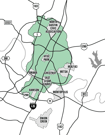
Smart Growth's Urban Core
The "urban core" defined in the city's Smart Growth plan corresponds to the boundaries of the city's urban watersheds, comprised of the following creeks: Johnson, Shoal, Waller, Boggy, Tannehill, and Fort north of Town Lake, and Bouldin, Blunn, and Harper's Branch on the south side.
Neighborhood Planning Program
This program of the city's Planning, Environmental & Conservation Services Department consists of seven planners who work with neighborhood representatives to produce a neighborhood plan. Expect this program to grow in the new budget year with an additional eight planners and four interns to keep up with the growing workload.
|
|

Neighborhood Plans
With only three neighborhood plans completed so far -- East Cesar Chavez, Dawson, and Chestnut -- and seven more in various points of the pipeline, the city is aiming to speed things up. Drafts are circulating right now of maps that would divide the entire urban core into 50 to 60 neighborhood planning areas and schedule a plan for each within the next five years. Here's the lineup so far:
| Completed: | In the Pipeline: |
| East Cesar Chavez | Onion Creek |
| Dawson | Old West Austin NA |
| Chestnut | Montopolis |
| METSA* | |
| North Austin Civic Association | |
| Hyde Park | |
| MLK / 183 |
* The area bounded by Martin Luther King, Ed Bluestein, Tannehill, Springdale, Airport
Neighborhood Services
While the city already has a Neighborhood Officer, there's talk of creating a neighborhood services system to handle such neighborhood needs as broken streetlights and other public services on a local basis. This system would include front-line staff at neighborhood centers located in each of the city's six police sectors.
Got something to say on the subject? Send a letter to the editor.