Tunnel Vision
The New Waller Creek
By Mike Clark-Madison, Fri., July 12, 1996


So concluded the Chronicle's last look, a year ago, at Austin's most glorious drainage ditch and the eternal question of what to do with it. Since then, an ambitious plan to reinvent Waller Creek -- clean it up, keep it from flooding and turn it into a commercially viable downtown destination -- has hit the table down at the Municipal Building.
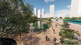
Though it only took eight consultants, led by the civil-engineering firm of Loomis and Associates, to prepare the new Waller Creek study, it's equal to the work of about 80 of Highsmith's 100 hypothetical hired-guns. The Loomis team projects that for as little as $16.7 million, the city can build a 17- to 21-foot-wide flood-diversion tunnel, running under Trinity Street for most of the creek's downtown section from Waterloo Park to Town Lake. This would allow Waller Creek to withstand major floods without busting its banks and bridges. During more typical dry spells, the tunnel will instead carry water from the lake back to Waterloo Park, from where it would flow back down the creek, turning what is now a fitful and stagnant stream into a constantly flowing (and thus cleaner and prettier) urban waterway.
With some additional work to prevent further bank erosion and improve water quality, the plan aims to make lower Waller Creek safer for citizens by making it less hospitable to the urban maladies (drugs, prostitution, vagrancy, etc.) it currently hosts. More to the point, the plan would make the creek -- especially the five blocks nearest the Convention Center -- safe for development a la the San Antonio Riverwalk, which would in turn spike city tax receipts high enough to pay for the tunnel in a trice, and a lot more besides. Beyond that, says Milosav Cekic, an urban design consultant who worked on the new plan, "development in Waller Creek can serve as a catalyst for development in the entire downtown area."
So let's see. Here we have a plan that, for the cost of, say, 1.4 minor-league ballparks (the standard unit of financial measurement in today's City of Austin), addresses the priorities of the city's three main political constituencies. By averting flood disasters, rectifying the public-safety meltdown along Waller Creek, and safeguarding previous investments in creek improvements -- including the Convention Center, and an upcoming $1.6 million rehab of the Waller Creek Hike and Bike Trail -- the Loomis plan speaks to the good-government, basic-services voter. By cleaning up the creek's revolting water quality (to the degree possible in a watershed that's 98% developed) and limiting pollutant discharge into Town Lake, and by preserving what, even with development, is a unique natural space in Central Austin, the plan passes muster with enviros and open-space advocates. And by making it possible for business interests to finally realize their 30-year-old dream of a "creekwalk" and kick-start downtown revitalization, the plan is mighty appealing to the booster and Chamber community.
All that, plus the fact that the New Waller Creek could potentially be paid for without soaking the city's General Fund for debt service, should make the idea likewise appealing to the city council and city manager, eh? So are you at all surprised that right now, four months after the plan's presentation, it sits gathering dust?
Or so it appears. The Loomis study, initiated last year by the Public Works and Transportation Department with $180,000 in funding from the drainage utility, was identified as Phase I of a three-part program; the following steps were identified back in February, when the study was released, as unfunded potential capital-improvement projects. And, from all indications, there they remain.
City Manager Jesus Garza alludes to $40 million in new debt issues for 1996-97 in his recently released "draft policy budget" -- fancy language for what is basically a tip sheet, letting lobbyists and activists know whose arms they need to twist between now and summer's end. Enough of that suggested capital spending is attached to other long-unfulfilled city promises to make the discovery of anywhere near $16.7 million for Waller Creek highly unlikely. Nor is there any indication of other funding sources for Waller Creek improvements, though Garza does declaim that his let's-do-lunch budget "allows for downtown renewal initiatives," unspecified.
Now, if the downtown community ever really acted as a unit, we'd have had a New Waller Creek about 20 years ago. To the extent that downtown shares a perspective now, it has noticed that city staff aren't visibly excited about Waller Creek. "We would very much like to see the Waller Creek project included in the new capital-improvements budget," says Downtown Austin Alliance (DAA) executive director Jose Martinez, "and clearly, it isn't now. It's a shame that the city doesn't seem interested in opening up its potential."
The city is moving forward on one Waller Creek project -- the rehabilitation of the hike and bike trail, first developed in the early 1980s but left unfinished and since damaged by recurrent flooding. Both then and now, the funding is from the Feds, this time via that most celebrated pork-barrel delivery system of modern times, the Intermodal Surface Transportation Efficiency Act, or ISTEA (pronounced "ice-tea"). This federal legislation has distributed a jaw-dropping amount of money for public-works projects of every description, some of which -- like Waller Creek -- actually have something to do with intermodal surface transportation efficiency. (Some of them -- like the State Cemetery restoration, also ISTEA-funded -- do not.)
Like the Loomis plan, the hike-and-bike project was slated to commence last summer, when we last reported on Waller Creek. You may have heard in the media since then about how the project was delayed by those pesky federal and state requirements. "We had to take some preliminary steps to make sure that we wouldn't disturb anything we shouldn't," says Stuart Strong of the Parks and Recreation Department, point man on the Waller Creek project. Strong adds that the requirements established by the Texas Department of Transportation (TxDOT), the local midwife for ISTEA funding, included a complete inventory of architectural and historical features in the project area. "Now that we've cleared the preliminaries for TxDOT," Strong says, "it's back in our hands. We're ready to move into the design phase."
The rest of the project, which Strong expects should be complete by Fall 1997, involves repairing those portions of the trail washed out in previous floods and, importantly, completing the unfinished segment of the trail between Cesar Chavez Street and Town Lake. PARD also plans to make the trail ADA-accessible and install signage and locator maps to help people orient themselves as they traverse the trail -- an essential element in any scheme for Waller Creek to become a pedestrian connector between the lake, the Convention Center, the entertainment district, and any development along its banks.
While there's a potential conflict in concepts between Waller Creek as a park and as an adjunct to downtown's retail and entertainment sectors, Strong and PARD -- who advised the Loomis team as they came up with their flood-control plan -- anticipate the new trail to be compatible with future developments. "We've already had experience with working with developers to ensure public passage along the creek," says Strong, pointing to the Sheraton and Marriott hotels as examples. "Most developments see an open creek as an amenity."
Instead, Strong says, PARD's greatest concern with the Loomis plan was integrating the actual tunnel, or more precisely its openings in Waterloo Park and along Town Lake, with the parks at those locations. "If you have these new structures along the trail, we want them to be seen as minimal intrusions by the public, if not actually incorporated into the landscape. We want them to be park features, and that can be done." The Loomis plan calls for the outlet at Town Lake to be topped by a gazebo, and the intake at Waterloo Park to be hidden under the 15th Street bridge.
That the Loomis plan at- tains this level of detail is fairly remarkable, considering that the study was executed in less than six months. Then again, the main ideas in the plan are not really new. Local architects and planners have proposed a tunnel-and-pump system to combat Waller Creek floods and stabilize the creek's water level since at least 1968. A system similar to the one in the Loomis plan was included in the 1976 Lower Waller Creek Development Plan, the last "master plan" for the area, which begat the current hike-and-bike trail. A 1985-86 study by the engineering firm Camp Dresser and McKee explored preliminary concepts for a flood bypass tunnel (The firm also pitched in on this project). Other themes of the Loomis plan appear in the Town Lake Comprehensive Plan and its ephemera, in the Convention Center's district design guidelines, and in the 1991 Regional/Urban Design Assistance Team (R/UDAT) report.
What ultimately makes the current plan different is its union of hard-core engineering and urban-planning visioneering into one conceptual framework. The Loomis plan articulates in fairly numbing detail how to create a new Waller Creek -- the difference between an 18-foot-wide tunnel and a 21-foot wide one, exactly how high the water flows over each of the 14 bridges from 15th Street south, the pros and cons of each of 25 upstream sites for water-quality retrofits. It also embraces the equally, if not more, important question of why to create a new Waller Creek.
And the answer to that question, simply stated, is to encourage development along the Waller Creek corridor. Last year, before the Loomis study got off the ground, local planners and architects enlisted the aid of Councilmember Jackie Goodman to ensure that urban-design issues be addressed in the project. Of the resulting three goals approached by the planners -- flood control, improved water quality, and increased urban development -- the latter is the one that makes the project financially feasible.
Purely on the basis of flood control, a New Waller Creek is a bum investment, no matter how nasty the current creek's floods are. The Loomis study identifies the annualized cost of Waller Creek flooding (that is, the damages from big storms added up and averaged out) at approximately $300,000 a year, while the $16.7 million price tag, plus interest, spread out over the 50-year assumed life of such projects, works out to around $650,000 annually. (Real live municipal bonds, of course, are on a 30-year term, so actual debt service would be about $1.1 million a year over that term.) This low cost/benefit ratio makes it unlikely that the city can get funding from the usual flood-control sources like the U.S. Army Corps of Engineers, which cares not a whit about downtown renewal. The additional water-quality improvements included in the plan, which account for about $3 million of the initial capital investment, create "unquantifiable" benefits, i.e. not very impressive in dollar-sign terms.
Start adding in the increased property, sales, and liquor taxes that new development would bring to the city, though, and you're looking at a 100-year flood of money down Waller Creek. The Loomis study includes two development scenarios -- identified as low- and high-density -- though they are basically limited to the area right near the Convention Center, between Cesar Chavez and Fifth. The low-density scenario, which consists of two new restaurants, one retail block, one apartment building, and one parking garage, adds more than $200,000 annually in tax revenue to the city's coffers. The high-density scenario is fairly more ambitious, including a new convention hotel, a dozen new restaurants, several blocks of retail, 265 new residential units, and 5,000 new structured-parking spaces. This scenario would add $1.4 million in tax revenue annually to the General Fund, easily paying for the Waller Creek investment and then some.
This second scenario is pretty shoot-the-moon and likely invites a citizen backlash strong enough to scare famously skittish downtown investors, if not more strong-stomached city councilmembers. But the first scenario -- which comes within five figures of the annual break-even point -- doesn't involve much more revitalizing than is going on now in the warehouse district, without any city assistance or incentive, and it would likely not catch hell from the aggrieved populace, since much of the land in question is near-derelict as it is. So even without full-scale Riverwalk action along Waller Creek, it seems quite feasible that, even if the city continues to deal with downtown in its traditional impotent and scatterbrained fashion, enough people will move into Waller Creek on their own to make the project worthwhile.
Of course, the planning- and-design community does not want the City to proceed in its traditional fashion. The urban-design analysis contributed to the Loomis study by Milosav Cekic is often fairly broad -- Waller Creek deserves development; eliminating the flooding threat will allow construction below the 100-year flood level a la the Riverwalk; cleaning up the creek will improve its appeal and make development that much more viable. (It wouldn't seem that the fairly rank water quality in the San Antonio River deters customers from the Riverwalk, but Austin is different that way.)
Much of Cekic's focus is on the "range of economic, planning, urban design, and political obstacles to development (that) exist for Waller Creek." These include the disinterest of political leaders, public antipathy to big-dollar government spending, the negative image attached to Waller Creek due to its current crime and homelessness problems, and "the lack of a clear planning vision for the downtown area." The study proposes not only the inevitable master plan for the Waller Creek corridor, but the definition of the corridor as a redevelopment area managed by a redevelopment authority, with special planning and land-use rules and financing mechanisms in place.
This last idea may prove to be the side door through which this plan gets carried into City Manager Jesus Garza's field of vision. Ever since the R/UDAT report in 1990, which led to the creation of the downtown public-improvement district wherein property owners pay for the services provided via the Downtown Austin Alliance, revitalistas have kicked around the creation of a tax increment financing (TIF) district to pay for downtown projects more capital-intensive than the DAA's jazz concerts and new Christmas decorations for Congress Avenue. A TIF district involves setting boundaries within which, for a specified time period, any tax revenues over and above what is being collected now -- in this instance, the $200,000 or $1.4 million or somewhere in between from new Waller Creek development -- would go directly to retiring debt for district-specific capital improvements. In most of its Texas applications, the TIF district includes a specific large property, such as a shopping mall, and nothing else.
While there has been some speculation about creating a TIF district that just encompasses the Waller Creek corridor, there's more interest in a downtown-wide TIF, and the DAA's Martinez feels the downtown community "is demanding that the city create a TIF district as quickly as possible." In return, the DAA intends to identify a list of public works projects that have the support of both the city and its various downtown stakeholders.
To date, this has been a very short list. However, Martinez argues, "I think Waller Creek would loom high in priority among capital projects for downtown. It's an area that's prime for development, that's key to fostering development elsewhere in the central city, and the current state of the creek is merely delaying that potential."
Got something to say on the subject? Send a letter to the editor.