Day Trips
Two new guides lead the way to some hidden Central Texas jewels
By Gerald E. McLeod, Fri., Feb. 27, 2004


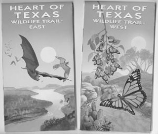
Two new nature trail guides give directions to hidden jewels that make Central Texas special. The Heart of Texas Wildlife Trail West and East maps are based on the popular Texas Coast Birding Trail series of maps. Illustrated with beautiful watercolor artwork by Ross Carnes, the pair of driving tours covers 55 counties, 239 wildlife-viewing sites, and hundreds of scenic miles of highways and back roads.
Published by the Texas Parks and Wildlife Department with assistance from the Texas Department of Transportation, the color maps give nature tourists and day trippers the inside track to prime sites for seeing the largest bat cave in the state, prehistoric rock art, the state's oldest Spanish mission, one of the state's last suspension bridges, the world's largest surviving herd of scimitar-horned oryx, and many other unique sites.
In addition to detailing some of the natural wonders of South and Central Texas, the guides offer hints on places to eat, like Lookout Mountain (512/847-5010) outside of Wimberley, places to stay, like Neal's Lodges on the Rio Frio near Leakey (830/232-6118), and little-known local parks, like Castroville Regional Park on the Medina River in Castroville.
The foldout maps can be used as road maps, guides to pick a destination, or simply for starting a meandering Sunday drive. Be sure to bring the binoculars, and in many cases don't forget the canoes and mountain bikes. You might even want to bring the checkbook for a shopping spree at the Medina Garden Nursery in Bandera (830/589-2771) or at Texas Hills Vineyards (830/868-2321) north of Johnson City.
On the central flyway for migrating birds between North America and Central and South America, the Central Texas region is one of the most diverse wildlife regions in the state. The eastern wildlife trail stretches along the I-35 and U.S. 183 highway corridors from Laredo to Brownwood. Divided into 14 loops with 124 sites, this is a diverse area from the mesquite-covered plains south of San Antonio to the rugged, juniper-covered hills north of Austin.
Two driving loops on the eastern map will guide you to explore the natural wonders of the ninth largest city in the U.S. San Antonio provides multiple opportunities to see kingfishers, woodpeckers, hummingbirds, and herons as well as take a hike, explore historic sites, or visit a world-class zoo.
The trail guide might even open your eyes to recreational facilities available around the Austin area. Most everyone knows about the Congress Avenue bat colony, but how many know about Red Bud Isle Park below Tom Miller Dam or Lost Pines Nature Ranch near Bastrop?
My personal favorite of the two maps is the western wildlife trail, but only because it has a wide variety of things to see and do, from the evening emergence at the Eckert James River Bat Cave (325/347-5970) outside of Mason to viewing the Native American rock paintings at Paint Rock (325/732-4376). The map even includes two canoe trails on the Guadalupe River.
The Heart of Texas Wildlife Trail maps join the Panhandle Plains Wildlife Trail that was published in August 2003. According to TPWD, a third installment in the series, the Prairie and Pineywoods Trail, is in the works. The trail guides, along with the Texas Coastal Birding Trail, are available for free from the state's 12 Travel Information Centers, including the Capitol Visitors Center in the Old Land Office on the Capitol grounds. The maps can also be purchased for $3 through the Texas Cooperative Extension Bookstore at www.tcebookstore.org or by calling 888/900-2577.
If your map needs are a bit more utilitarian, then MAPSCO might have the perfect new book for you. The first edition of the MAPSCO Texas Atlas and Travel Planner includes more than 1,100 pages of state, county, and city maps. While the detail isn't as minute as the TxDOT county maps (486-5014 or txdot.lib.utexas.edu), the 81/2-by-11-inch books are the perfect size for exploring back roads or city neighborhoods. The atlas is available at MAPSCO retail locations and online at www.mapsco.com.
The Dallas-based map company began as an extension of a busy flower-delivery business. Boyd Keith produced the first Dallas Street Guide in 1952 to aid his delivery personnel. Today MAPSCO publishes maps, software, and custom maps of major Texas metropolitan areas, as well as operating retail Map & Travel Centers around the state.
663rd in a series. Day Trips, Vol. 2, a book of Day Trips 101-200, is available for $8.95, plus $3.05 for shipping, handling, and tax. Mail to: Day Trips, PO Box 33284, South Austin, TX 78704.